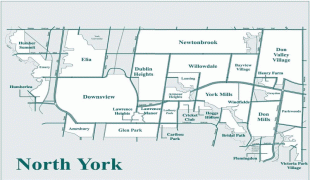
North York (North York)
North York was created as a township in 1922 out of the northern part of the former township of York, a municipality that was located along the western border of Old Toronto. Following its inclusion in Metropolitan Toronto in 1953, it was one of the fastest-growing parts of the region due to its proximity to Old Toronto. It was declared a borough in 1967, and later became a city in 1979, attracting high-density residences, rapid transit, and a number of corporate headquarters in North York City Centre, its central business district. In 1998, North York was dissolved as part of the amalgamation which created the new city of Toronto. It has since been a secondary economic hub of the city outside Downtown Toronto.
The was formed on June 13, 1922 out of the rural part of the Township of York. In the previous decade, the southern part of York, bordering the Old City of Toronto had become increasingly urbanized while the northern portion remained rural farmland. The northern residents increasingly resented that they made up 20% of York's tax base while receiving few services and little representation in return, particularly after 1920 when their sole member on York's council, which was elected on an at-large basis, was defeated. Dairy farmer Robert Franklin Hicks organized with other farmers to petition the Ontario legislature to carve out what was then the portion of York Township north of Eglinton Avenue to create the separate township of North York. With the support of the pro-farmer United Farmers of Ontario government, a plebiscite was organized and held and the 6,000 residents voted in favour of separating from York by margin of 393 votes.
The township remained largely rural and agrarian until World War II. After the war, in the late 1940s and 1950s, a housing shortage led to the township becoming increasingly developed as a suburb of Toronto and a population boom. In 1953, the province federated 11 townships and villages with the Old City of Toronto, to become Metropolitan Toronto.
As North York became more populous, it became the in 1967, and then on February 14, 1979, the. To commemorate receiving its city charter on Valentine's Day, the city's corporate slogan was "The City with Heart". It now forms the largest part of the area served by the "North York Community Council", a committee of Toronto City Council.
North York used to be known as a regional agricultural hub composed of scattered villages. The area boomed following World War II, and by the 1950s and 1960s, it resembled many other sprawling North American suburbs.
On August 10, 2008, the Toronto propane explosion occurred at the Sunrise Propane Industrial Gases propane facility just southwest of the Downsview Airport. This destroyed the depot and damaged several homes nearby. About 13,000 residents were evacuated for several days before being allowed back home. One employee at the company was killed in the blast and one firefighter died while attending to the scene of the accident. A follow-up investigation to the incident made several recommendations concerning propane supply depots. It asked for a review of setback distances between depots and nearby residential areas but didn't call for restrictions on where they can be located.
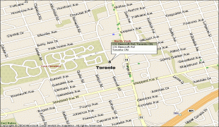
Canada's deadliest pedestrian attack occurred in the North York City Centre district on April 23, 2018 when a van collided with numerous pedestrians killing 10 and injuring 16 others on Yonge Street between Finch and Sheppard Avenues.
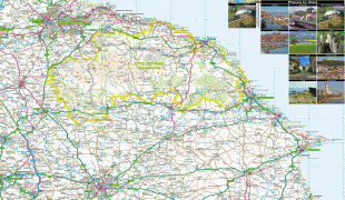
Map - North York (North York)
Map


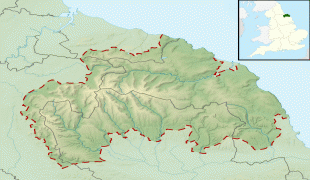


Country - Canada
 |
 |
| Flag of Canada | |
Indigenous peoples have continuously inhabited what is now Canada for thousands of years. Beginning in the 16th century, British and French expeditions explored and later settled along the Atlantic coast. As a consequence of various armed conflicts, France ceded nearly all of its colonies in North America in 1763. In 1867, with the union of three British North American colonies through Confederation, Canada was formed as a federal dominion of four provinces. This began an accretion of provinces and territories and a process of increasing autonomy from the United Kingdom. This widening autonomy was highlighted by the Statute of Westminster 1931 and culminated in the Canada Act 1982, which severed the vestiges of legal dependence on the Parliament of the United Kingdom.
Currency / Language
| ISO | Currency | Symbol | Significant figures |
|---|---|---|---|
| CAD | Canadian dollar | $ | 2 |
| ISO | Language |
|---|---|
| EN | English language |
| FR | French language |
| IU | Inuktitut |